Information |
|---|
| ?} |
 |
||||
| Demographics | |||||
| ?} | Connellsville, PA's largest employers are the Connellsville Area School District, and Highlands Hospital. | ||||
| Geography | |||||
| ?} | Communities bordering Connellsville, PA include Connellsville Township, PA, Dunbar Township, PA, and South Connellsville, PA. | ||||
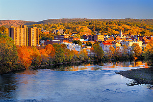
| ?} | Connellsville, PA straddles the Youghiogheny River and is at the western base of Chestnut Ridge, which is known locally as the start of the "mountains." | ||||
| ?} | Connellsville, PA is located approximately 50 miles southeast of Pittsburgh, PA. Quickest route (approximately 1 hour) to Pittsburgh, PA from the Connellsville, PA is Route 119 north, I-76 west, and I-376 west to downtown Pittsburgh, PA. | ||||
| History | |||||
| ?} | Connellsville, PA was incorporated as a borough in 1806, but became a city after annexing the former borough of New Haven, PA in 1909. The former community of New Haven is now referred to as the "West Side of Connellsville", as it is west of the Youghiogheny River. | ||||
| ?} | The first newspaper published in Connellsville, PA was "The Connellsville Herald" in 1815. That venture soon folded and a second attempt was made in 1855 with "The Connellsville Enterprise," which changed its name to "The Fayette Patriot" in 1859 before succumbing to failure. "The Fayette Monitor and Youghioghenian" became the first permanent paper in Connellsville, PA that started April 12, 1870, its operations were later absorbed by "The Connellsville News" in 1898. On July 17, 1879 "The Keystone Courier" appeared that later dropped the "Keystone" to become "The Courier." | ||||
| ?} |
Original roads for the 1806 Connellsville, PA borough were
|
||||
| Living | |||||
| ?} | Public education for Connellsville, PA is provided by the Connellsville Area School District. | ||||
| ?} |
Utility companies serving Connellsville, PA include:
|
||||
| ?} | External Web Link: Official Web Site for Connellsville, PA (City Government) | ||||
| ?} |
|
||||
| Transportation | |||||
| ?} | Connellsville, PA's major state roads are Route 119 (four lanes), Route 711 (Crawford Avenue), and Route 201. The city's main street is Pittsburgh Street. Other major roads include Arch Street, and Breakneck Road. | ||||